Google Maps Now Adds Live Augmented Reality Navigation
Map reading has come a long way from the old paper maps and compasses to GPS. For the directionally hopeless, things have been getting considerably better by the day with the roll out of apps such as Google Maps and finally, incorporation of augmented reality maps tools.
Google is elevating the game even further by launching its new Live View augmented reality walking directions feature for its Google Maps that will help users visualize the map through the real world.
The new AR Live View is available for both Android and iPhone and will integrate the navigation cues into the user’s real-world surroundings to provide a quick orientation where GPS fails as long as Street View is available at the location where the user is. It will offer a virtual directions functionality that will show the user where they need to head to, thereby giving them more precise help in figuring out the directions. The new Live View tool is expected to help simplify users’ journeys in unfamiliar places.
Google Maps meets AR.
Rolling out to Pixel phones, starting today. #io19 pic.twitter.com/rDBxvbZyF8
— Google Maps (@googlemaps) May 7, 2019
The live augmented reality navigation feature for Google Maps will be available for both ARKit and ARCore -compatible smartphones and will be rolling out this week. For now, it will be in beta status. Check out the list of the ARKit-compatible phones and the ARCore-compatible phones here.
The Augmented Reality Navigation Feature Begins in Live Beta
This feature was first revealed at the 2018 Google I/O and launched earlier this year in Google’s Pixel phones. The AR feature was available in the alpha mode for Google’s Pixel phones and for the Google Maps Local Guides. From today, the feature will roll out on the non-Pixel Android phones that run ARCore and to iPhones running ARKit. The roll-out might take weeks and will be subject to when the update will be pushed to end users.
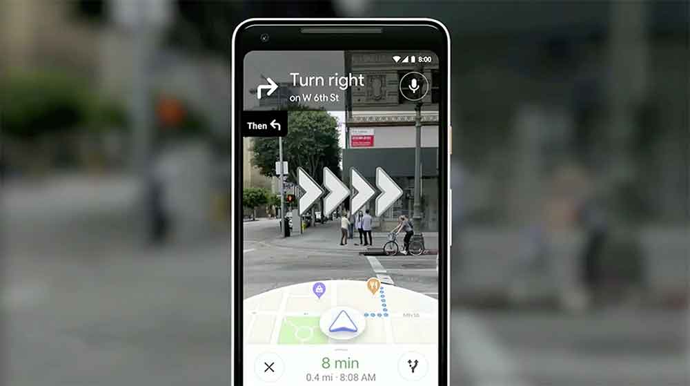
Features-wise, the new version is quite similar to the previous version that was released in March. It has various features such as the ability for users to tap on any nearby location in Maps. Users can also tap on its “Directions” button and navigate their way to “Walking”, then tap on “Live View” which they will find close to the bottom of the screen.
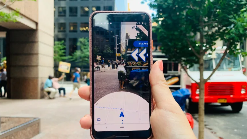
The Live View feature in the Google Maps offers users a quick and easy orientation by showing them arrows along with the big and readable street markers that will be overlaid on the real environment right in front of them. The feature has not been built with the view of the user holding up their smartphones constantly as they walk to figure out directions. It is more of an orientation-style functionality. When a user opens the Live View, they will be able to quickly orient themselves in any unfamiliar setting, a feature that can be hugely beneficial if you are travelling in an unfamiliar place.
Combining GPS With Visual Positioning
The new feature leverages both GPS and machine vision to quickly orient users on where they currently are. The users scan their environment via the smartphone camera to get visual clues such as a prominent landmark. The feature then matches this image with the Google Street View shots. So it only works where a Street View is available.
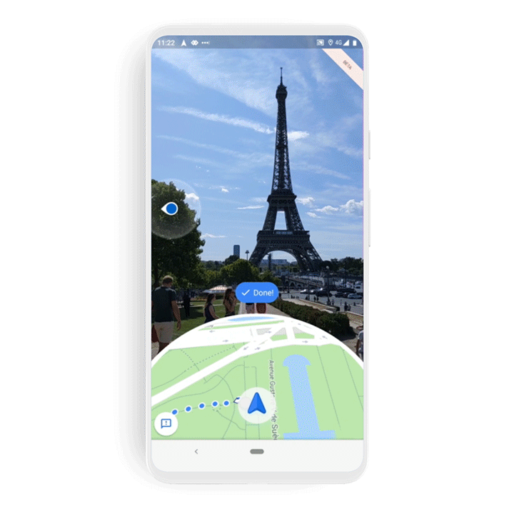
By bringing these two data sets together -GPS and Street View shots- the Google Maps feature will be capable of positioning the user’s point of view more precisely than when they use pure GPS positioning and it also places the digital signage in the right place. It will visually highlight key areas such as the cafes and shops. The visual matching is known as Visual Positioning Service.
From an AR Gimmick to a Practical City Guide
The AR feature is growing from a gimmick into a useful city guide. The AR navigation is deactivated when a user holds their smartphone normally but it reactivates when the smartphone is aimed at the scene.
Apart from this, Google Maps is currently undergoing several upgrades which include a one-stop “Reservations” tab in the Google Maps for which stores flight and hotel accommodation information. This is even backed up offline. Then there is the redesigned Timeline which is currently available on Android devices and will be rolling out to users in a couple of weeks.
https://virtualrealitytimes.com/2019/08/09/google-maps-now-adds-live-augmented-reality-navigation/https://virtualrealitytimes.com/wp-content/uploads/2019/08/Google-Maps-Live-View-600x338.pnghttps://virtualrealitytimes.com/wp-content/uploads/2019/08/Google-Maps-Live-View-150x90.pngAugmented RealityTechnologyMap reading has come a long way from the old paper maps and compasses to GPS. For the directionally hopeless, things have been getting considerably better by the day with the roll out of apps such as Google Maps and finally, incorporation of augmented reality maps tools. Google is elevating...Sam OchanjiSam Ochanji[email protected]EditorVirtual Reality Times - Metaverse & VR